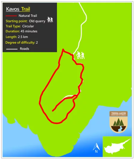
ACTIVITIES
NATURE TRAILS

Agioi Anargyroi (Circular)

– Starting point: Church of Agioi Anargyroi Length: 2.3 km – Duration: 45 minutes – Degree of difficulty: 1
– Points of interest: Dense vegetation, mainly Phoenician Juniper and a picnic site.

Agioi Anargyroi – Thalassines Spilies (Linear)

– Starting point: Church of Agioi Anargyroi Length: 4 km – Duration: 1.5 houres – Degree of difficulty: 1
– Points of interest:A beautiful walk along the coast. The sea caves are accessible only by sea and the area is suitable for diving. The trail goes over the natural bridge “Kamara tou Koraka”. Links with Konnos- Agioi Anargyroi, Sea Caves and Kavos trails.

Kavos (Circular)

– Starting point: Old quarry, parking area. Access from Agia Napa-Cape Greko main road, near the Cape. Length: 2.5 km – Duration: 45 minutes – Degree of difficulty: 2
– Points of interest:An old quarry, a large number of fossilized marine organisms, and a vantage point at the peak of the Cape from which one can see as far as the Stavrovouni Monastery. On a very clear day the heights above Haifa in Israel, are visible. The impressive cliffs are suitable for climbing.

Konnoi – Agioi Anargyroi (Linear)

– Starting point: Konnoi Beach Length: 1.4 km – Duration: 30 minutes – Degree of difficulty: 1
– Points of interest:A walk along the coast which ends at the little church of Agioi Anargyroi, built over a sea cave which, according to tradition, was the home of St. Kosmas and St.Damianos.

Konnoi – Spilia Kyklopa (Cyclopas Cave) (Circular)

– Starting point: Konnos beach, between Protaras and Cape Greko. Length: 2.4 km – Duration: 45 minutes – Degree of difficulty: 1
– Points of interest:A walk along the coast leading to natural caves, the best known of which is the Cyclopas cave. A kiosk operates on Konnoi beach.

Panagia – Agioi Saranta (Linear)

– Starting point: Church of Panagia. Sideway in a distance of 300m on the left of the Cape Greko – Protaras street, towards Protaras. (b) Agioi Saranta. Access from Protaras through dirt roads. It connects with the Profitis Elias – Konnos and Panayia – Ayiou Ioanni trails. Length: 2.5 km – Duration: 45 minutes – Degree of difficulty: 1
– Points of interest:The graphic Chappel of Agion Saranta.

Panagia – Agios Ioannis (Linear)

– Starting point: (a) Church of Panayia. Sideway to a 300m distance on the left of the Akrotirio – Protaras street, towards Protaras. (b) St. Ioannis Church. Access from Protaras though dirt roads. It connects with the Profitis Elias – Konnos and Panayia – Agioi Saranta paths. Length: 2.8 km – Duration: 45 minutes – Degree of difficulty: 1
– Points of interest:The graphic Chappels of Agiou Ioanni and Agion Saranta.

Profitis Elias – Konnoi (Linear)

– Starting point: (a) Chappel of Profitis Elias of Protaras. Access from the Cape Greko – Paralimni street. (b) Konnos Beach, between Protara and Cape Greko. Length: 8.5 km – Duration: 3 hours – Degree of difficulty: 1
– Points of interest:Panoramic view from the Chappel of Profitis Elias. The route includes the Chappels of the Agion Saranta and Agiou Ioanni. It ends to the Konnos Beach. It also connects with the trails Panayia – Agioi Saranta, Panayia – Agios Ioannis, Konnos – Agioi Anargiroi and Konnos – Spilia tou Kyklopa.

Thalassines Spilies (Sea Caves) (Circular)

– Starting point: (Sea Caves. Agia Napa-Cape Greko road, 6 kms east of Agia Napa. Length: 3.6 km – Duration: 1.5 houres – Degree of difficulty: 2
– Points of interest:A walk along the coast which at certain points is very steep and craggy.